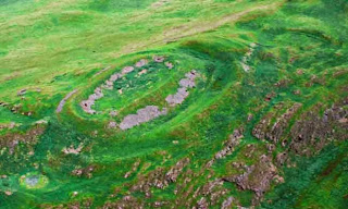
The place photographed is 'The Belt' near Hightownhead,
Dalswinton and is what remains of a hillfort. The fort and the trees are
shown on the 1861 25” map (Dumfries Sheet XLI.9). The fort at this time was thought to be
'Danish' i.e. Viking but this does not seem to be correct.
It is an Early Iron Age (600-400 BC) promontory fort and unusual because its defensive walls are built of stone rather than being earth banks. The fort occupies the edge of a high terrace and measures internally 50.0m E-W by 30.0m. There is a double rampart round the fort and an entrance way at the South-East. It is now very overgrown with substantial old trees and brackens. No artefacts are recorded as having been discovered near the fort.
Promontory forts are frequently found on the coast where
there are cliffs which jut out into the sea,
In this case, the topography with its very steep ascent from the Nith
Valley creates a similarly good defensive site.
On the other side of the road from the fort is a spring
which has three ancient alder trees around it.
They were mature trees at the time of the 1861 map. It is probable that this spring provided
water for the inhabitants of the fort.
Alder wood does not rot in wet conditions. For this reason it was used to build the
supporting frames for crannogs.
Our photos show the remains of a fort in this area. Crannogs have been found at Lochrutton and Loch Arthur.
Our photos show the remains of a fort in this area. Crannogs have been found at Lochrutton and Loch Arthur.
(A crannog[[ˈkɾˠan̪ˠoːɡ]; Scottish Gaelic: crannag) is typically a partially or entirely artificial island, usually built in lakes, rivers and estuarine waters of Scotland and Ireland. Unlike the prehistoric pile dwellings around the Alps which were built on the shores and were only inundated later on, crannogs were built in the water, thus forming artificial islands.)


No comments:
Post a Comment